Introduction
Hiking, although an activity open to all, carries its risks.
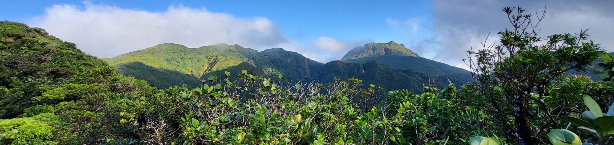
Embarking on a one or several-day journey into an isolated mountain area, such as the Trace des Alizés,
requires thorough reflection and meticulous preparation.
This section offers you practical advice and feedback from experience.
However, it's crucial to remember that: each hiker undertakes mountain
activities at their own risk.
For those wishing to have guidance, professional guides are available.
These nature and mountain experts are there to safely explore this exceptional territory that the Park
offers.
Do not hesitate to contact the Association of Mountain Guides of Guadeloupe (AAMG) by email at the following
address: aamg971@gmail.com.
Remember, the goal of this page is above all to share feedback from experience to help you better prepare
your adventure on the Trace des Alizés.
Preparation Before Leaving
Necessary Skills
-
Autonomy Experience
This particularly challenging hike is not recommended for a first experience of multi-day trekking in
autonomy.
Prior experience in similar conditions is strongly advised to ensure hikers are prepared for the
specific challenges of the Trace des Alizés.
Stages 1 and 2 alone are suitable for a first experience with a night in a shelter.
-
Physical Preparation
A good physical condition is essential to cope with the demand of long days of mountain walking.
The preparation must also take into account adaptation to the tropical climate, which can be
particularly challenging and influence physical performance.
-
Orientation
Proficiency in reading an IGN map and using a hiking GPS is essential for effectively navigating in
mountainous terrain, mandatory for stages 3, 4, and 5.
-
Mental Resilience
Hikers must be prepared to face isolation in nature, manage consecutive days of rain without seeing
the sun, and endure wearing wet clothes for long periods. For stage 5, the ability to walk more than
12 hours and to walk at night is also crucial.
-
Communication
Being able to maintain constructive communication with group members, even in moments of stress or
fatigue, is vital for the well-being and safety of all.
Planning and Safety
-
Never go alone
The Trace des Alizés is a remote mountain area where encounters are rare (in five days, we only met 3
people).
Going accompanied is a basic safety rule to ensure help is available in case of an accident on
sparsely traveled paths.
-
Inform your loved ones
It's crucial to inform loved ones of your hiking plans, including estimated departure and return
dates.
Attempting to communicate your position daily is a reassuring and safe practice for everyone.
-
Prepare your phone for emergencies
Having a charged phone to call for help is essential.
Note that network coverage may be non-existent over much of the route, so be prepared for emergency
communication.
-
The ability to give up
It's vital to stay lucid in the face of changing conditions and to know when to give up if conditions
become dangerous.
Safety must always take precedence over completing the route.
-
Write in the shelter book
Leaving a record of your passage in the shelter book is an important safety measure.
In case of disappearance, this information can help search teams determine your last known point of
passage and narrow down the search area.
Trail Conditions
The Trace des Alizés traverses a tropical environment that can be affected by extreme weather conditions,
such as cyclones, floods, landslides, and earthquakes. These events can cause significant damage to trails,
as was the case during storm Fiona in 2022.
The importance of this factor, often underestimated, was a hard lesson for us, leading to the abandonment of
our hike when we were so close to the goal. This is the main reason for the creation of this site: to
provide regular updates on the trail conditions to help hikers plan their route with the most recent
information, to avoid being surprised by impassable passages.
Online resources can provide updated information on trail conditions:
Weather
Guadeloupe enjoys a tropical climate divided into two seasons: a dry season from December to May and a
cyclonic season from June to November.
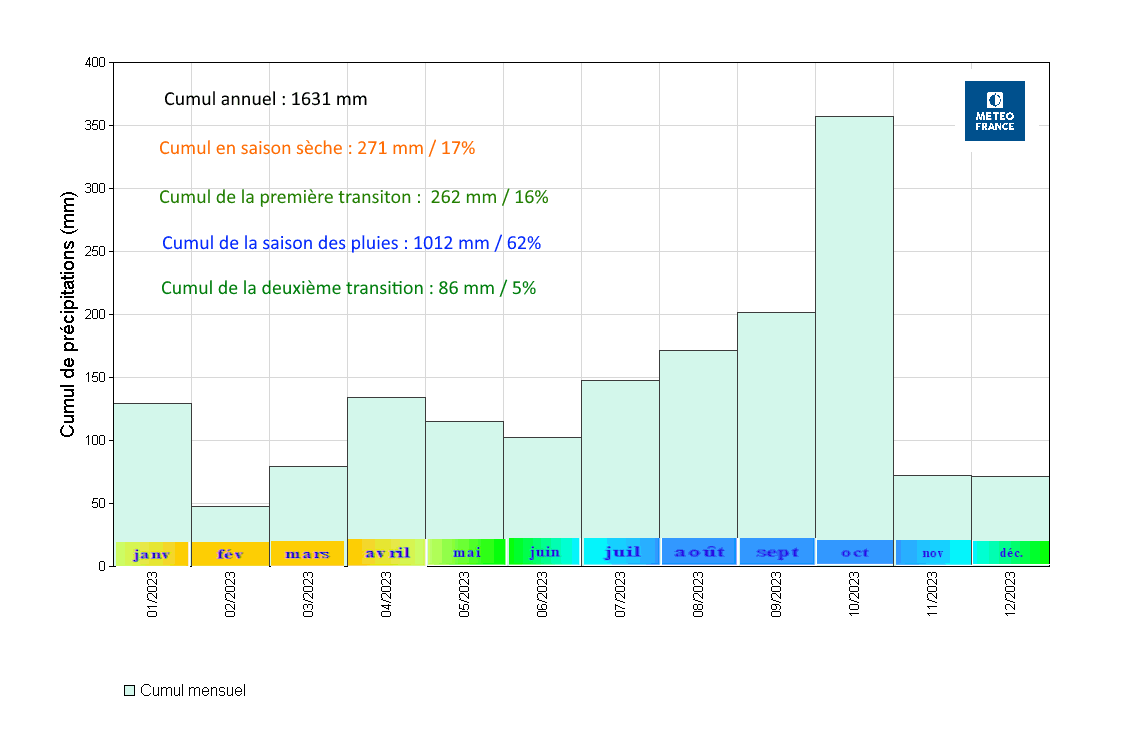
The rain statistics for 2023 show a decrease in precipitation during the dry season, with February and March
being the most favorable months for hiking. Conversely, the period from August to October, marked by a high
cyclonic risk and heavy rainfall, should be avoided.
Even though it's dry, this season is not free of rain, especially in the more humid Basse-Terre region.
Thus, encountering consecutive days of rain is possible. The main risks are heavy rains that can cause
landslides and river floods, increasing the danger for hikers.
It's essential to stay informed through Météo France Guadeloupe alerts and to use apps like Windy to
anticipate major disturbances. Even during the cyclonic season, July and November present a lesser risk and
can offer good conditions for hiking, provided the weather forecasts are checked.
Equipment and Gear
What follows is a list of the gear we used during our hike, which might also be useful for you.
Orientation
- IGN Maps: The two IGN maps 4602 GT and 4605 GT found at Cultura Destreland and FNAC
Milenis.
- GPS: The Iphigénie app, which allows downloading
IGN maps in advance for use without an internet connection. A hiking GPS would also be perfectly
suitable.
Walking (per person)
- Trail shoes: Ideal for managing mud, with a special mention for their ability to let
feet breathe.
- Socks: Good socks to prevent blisters.
- Hiking shorts/pants: A set consisting of shorts and leggings for stages with dense
vegetation.
- 6 T-shirts: At the end of each stage, a dry T-shirt to wear for the night and for the
next stage.
- Windbreaker/waterproof jacket: Essential for protection against rain and vegetation.
- Gardening gloves: Essential for stages 3, 4, and 5 to handle vegetation without getting
injured.
- Walking stick: An entry-level model from Decathlon that held up well, indispensable
given the type of terrain.
- Cap and sunscreen: Useful for sections of the path exposed to the sun.
- Trekking backpack: A Quechua Symbium (70+10 liters) bag and a Forclaz MT500 Air (45+10
liters) bag.
Drinking (for 2 people)
- 5 water bottles of 1.5L: We started our hike with these reserves to ensure our initial
hydration.
- A Brita filtering bottle: Used to filter water we collected from rivers and rainwater,
ensuring safe drinking water throughout our journey.
- Micropur Forte tablets: Added to filtered water for additional purification, ensuring
the water is safe to drink and reducing the risk of illness.
The river water, supplemented by our filtration and purification system, was our main source of hydration.
Additionally, we also used the water from the refuge tanks, which we filtered and purified.
Eating (for 2 people)
- Hiking stove with a 410 ML bottle.
- 4 freeze-dried dehydrated meals (pasta bolognese and mashed potatoes) delicious!
- 4 portions of flavored semolina.
- 2 homemade banana breads for breakfast.
- Rye bread, tomatoes, cucumber.
- Seeds (cashews, almonds, hazelnuts).
- Dried fruits (prunes, apricots, figs).
- 4 grapefruits.
- Instant coffee.
Sleeping (per person)
- 15-degree sleeping bag.
- Hiking air mattress MT500 air.
- One-person mosquito net.
- Headlamp.
- Earplugs.
Miscellaneous
- 8 packs of tissues.
- First aid kit (essential bandages for blisters).
- Solid soap (a delight to wash each evening with water from the cistern).
- Toothbrush/toothpaste.
- String: Not used this time, but often useful.
The Shelters
The shelters are a major asset of this GR! Built in 1994 according to a unique plan, they offer almost
perfect uniformity.
Outside, each shelter has a table located under an awning, very practical for enjoying the last rays of the
sun of the day. They are also equipped with an 800-liter rainwater recovery tank, almost always well filled,
which is particularly appreciable for washing after a day spent in the mud.
The interior of each shelter is divided into two main spaces: a living room-kitchen with a large table and
hooks for hanging hammocks, and a dormitory with bunk beds that can accommodate up to 12 people.
All the shelters we used were clean and well-maintained, with the exception of the Frébault Shelter. The
Belle Hôtesse shelter regularly receives a visit from a rodent, but this did not pose a problem for us. On
the other hand, the Frébault Shelter had a broken main door, potentially allowing rodents to enter, and the
floor was littered with droppings.
For more information on the shelters, I invite you to consult this article from Zoom Guadeloupe
which presents beautiful photos of the shelters.
The article also offers suggestions for round-trip itineraries to reach each shelter, allowing to spend a
night without having to cover the entire GR.
Please note that the last update of this article dates back to 2016; therefore, the suggested itineraries
might have been modified or may no longer be accessible.